![]() Leader Church Cemetery
Leader Church Cemetery
Cut-off Date: 20 July 1998
Number of Burials: 41
Volunteers: Jane and Ernie Newman, Jan and Rusty
Winters, Milton D. and Mary Lou Lake, and Bill Gately
Special Thanks: Dorothy Baker, Margaret Gieck
Leader Church Cemetery is located approximately 50 miles southeast of Colorado Springs. From the eastern edge of Colorado Springs, take Highway 94 east for 24 miles to Yoder; turn south on Yoder Road and drive six miles; turn east on Fossinger Road and drive two miles; turn south on Boone Road and drive 14 miles; then turn east of Rasner Road and drive one mile. The cemetery and church are on the southeast corner of Edison and Rasner Roads. According to GPS-derived geolocation (accurate to within 10 meters), the cemetery's coordinates are latitude 38°32'57.9"N and longitude 104°09'51.4"W.
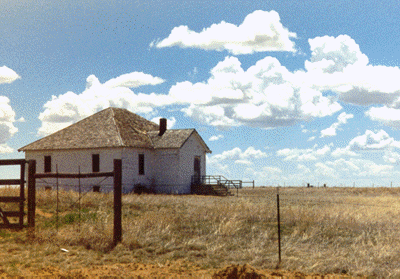
John Dzuris deeded three acres to Leader Methodist Episcopal Church in November 1918. At that time the trustees were J.T. Hamilton, Charles Gieck, W.H. Stroud, J.P. Hamilton, E.A. Vaulian, O.H.P. Stroud, and L.J. Stamps. The parsonage was built in 1926, but it was sold and moved in 1947. In 1942, two congregations, Leader and Edison, merged. The first known burial was in 1920 and the most recent was in 1964. A 1971 extraction by Athlyn Luzier was published in the Colorado Genealogist, volume 33, page 100. It does list additional relationships. In 1972 the local 4-H Club placed small concrete markers at each grave. Scratched onto the markers, the surnames are now difficult to read. Services in the church ended in 1979 and the building is deteriorating. There are no established visiting hours or regular maintenance. Farms and ranches bordered by dirt road surround the cemetery on this windy plain. Sexton records are held by Dorothy Baker, RR 2, 17055 Boone Road, Yoder, CO 80864.